Update on Haiku Stairs (3/15/2015):
Please note: On February 8th 2015, a powerful storm blew over the island, triggering a landslide that wiped out part of the Haiku Stairs. By all accounts, the stairs are now extremely dangerous, if not absolutely impassable. On the day of the storm, five hikers became trapped on the stairs and had to be rescued. In the days that followed, another young hiker went missing. As of today (more than a month later), he remains missing. Here are a few links to information on the storm and associated damage:
If you are thinking of climbing the Haiku Stairs, may I suggest one of the other many fantastic hikes that can be found on this beautiful island? If you're seeking a thrill, consider climbing Olomana. If you're looking for a fantastic view, consider hiking the Wa'ahila Ridge Trail to the summit of Mt. Olympus. What ever you do, have fun (and be safe)!
Mahalo,
-Steve
Yesterday, Cathie and I climbed the Haiku Stairs (aka "The Stairway to Heaven"). The climb offers an incredible aerobic workout, a look back at some World War II history, and absolutely terrific views of the Ko'olau Mountains and the windward side of Oahu.
Part of what makes this hike an adventure is that the trail is forbidden. The stairs are technically closed to the public and secured by a (friendly, but firm) guard who keeps people away. To make the hike, we had to sneak past the guard station at the base of the trail. This was accomplished by arriving in the wee hours of the morning, before the guard got there for the day.
The first time we attempted the hike, last year, we got to the trail head at 5 am -- after getting lost trying to find the place. The guard was there and turned us away. This time, we arrived around 3:30 am and managed to get by. Rumor has it the guard arrives around 4, but he wasn't saying for sure one way or the other.
"Oahu Revealed" by Andrew Doughty has a nice description of the Haiku Stairs, their history and their politics. Here are a few factoids.
- The hike is comprised of 3922 stairs, is about 2 miles long, and climbs 2200 feet in altitude.
- The stairs were built in WWII to support an anchor tower for a mile-long ultra-powerful radio transmitter that was supposed to be used to communicate with ships as far away as the Indian Ocean.
- The original trail was lined with wooden ladders. These were later replaced with wooden stairs, then metal ones.
- The trail was closed in 1987 due to vandalism. Repairs were made in 2005, but attempts to reopen the trail failed due to intra-government squabbling.
What follows is a brief chronology of our hike, supplemented with an abundance of pictures. I hope you enjoy them.
-Steve
Disclaimer: The photos below are organized as if hiking from the bottom to the top and back down again. In reality all these picture were taken on our descent. It was pitch black during the our ascent. In retrospect, I wish I had taken at least a few pictures (with flash) on the climb up. Oh well. Next time.
We began our day by waking up at 2:15 am. We left our place near Ala Moana around 2:30 and arrived at the "unofficial" parking area -- in the Haiku Village residential neighborhood -- around 3. We tried to be as quiet as possible, so as not to disturb the neighbors. We came across a pair of women who also were going to make the hike. While they waited for a friend to arrive, we pushed on.
We followed our instructions to reach the trail head. This time, we knew where to go, after getting lost last time. We hiked in the dark according to our instructions -- through fences, up roads, through forks, down trails, etc -- until we reached the trail head. We turned on our flashlights only twice to check our instructions.
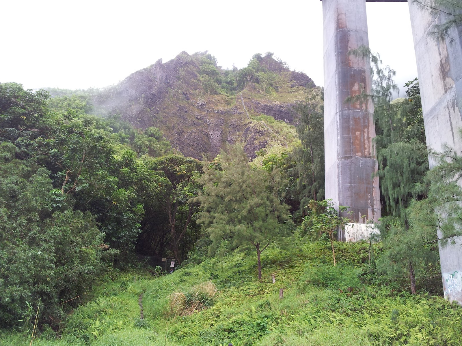
The trail head to Haiku Stairs is under the H-3 highway, in a fenced off area with "No Trespassing" signs on it. At the base of the stairs is a small blue tent, where the guard stays during the day.
When we got to the trail head we were happy to see no one. No guard. We started up the trail in the dark, worked around two fenced gates, and finally got onto our first set of stairs.
The stairs were steep and it was dark. However, once our eyes adjusted to the darkness we could more or less make out the next step in front of us. The sky was overcast, but there was a near-full moon, so we had some ambient light to guide us.
When we first started, I was taking two steps at a time. That lasted for about 3 minutes. My legs started to burn and I settled into a slower, steady, one-step at a time pace.
The stairs are comprised of segments. Each segment consists of seven steps. I discovered this as we climbed, while trying to think of anything but my legs. We climbed at least 150 segments (> 1000 steps) before reaching the first platform. I don't know the exact step count, but getting to the first platform was the longest leg of the hike for sure.
We climbed in the dark without flashlights since we'd been told that the guard will climb up to fetch you, if he sees your lights.
By the time we reached the first platform, I was drenched in sweat. We rested, drank water, and had a snack. Then, we continued on in the dark.
There weren't too many flat spots, mostly steep spots and very steep spots. In some places the steps were more ladder than stairs.
In most places the vegetation grows up and around the steps.
Cathie found, and I ate, a wild Hawaiian Raspberry. It was yummy.
There was beautiful vegetation all around. Here is a nice fern. We also saw wild orchids, yellow moss, octopus (rubber) trees, and more.... all on the way down.
Did I mention there are a lot of stairs?
At another platform, there was a structure that was used as a way-point for hauling equipment to the top. It was covered in graffiti, some of which is nice. We took a short rest here as well.
I wondered how they managed to get all this equipment up there in the first place.
There was more hauling equipment, and ...
... encouragement to keep going.
The stairs continued to climb.
At some points, we had to hold the underside of the rails to keep from falling backwards.
The stairs inevitably led into the clouds, where it was cool (cold by HI standards) and wet. When it wasn't misty, it rained. And in places the wind blew hard. It was disconcerting in the dark.
Eventually, we reached the top. It was about 5 am and still dark. The ascent took about 1.5 hours. At the top there was a small cement bunker, with a couple of dish antennas on the top. (Note: The picture above, was taken around 5:45, just before dawn, on our way down).
We waited for dawn in the bunker with a handful of other hikers. We were cold and wet, but the food was good and the company friendly.
A little before dawn, we decided to head out. It was blowing and raining.
We worked our way along the ridge, down out of the clouds.
In spots, the descent was steep, like going down a ladder backwards. It was kind of freaky. In this picture, you can see H-3 far below.
We found more inspiring messages at the way-station.
Thankfully, coming down was easier than going up. As we dropped below the clouds we dried off and warmed up.
We still had a long way to go. But, we took our time, enjoyed ourselves and took plenty of pictures.
We got a good view of the H-3 Tunnels from the ridge.
Neither Cathie, nor I slipped once during the hike. Even though the stairs were wet, we never seemed to have a problem with traction.
The flowers were beautiful. This one is called Lantana.
... more stairs... steep in spots.
We got on intimate terms with the stairs both climbing up and coming down.
Finally, we came over the last hump and could see H-3 and the trail head below. If you look closely at the picture above, you may be able to spot the guard standing in the clearing, under H-3, just to the left of that central pillar.
We dropped below H-3, toward the trail head.
The guard greeted us when we got back. "Hello Trespassers," he said. He was friendly and pleasant. It was about 8 am, 4.5 hours after we started.
Rather than retrace our steps back to the car, we went in the direction suggested by the guard. Somewhere we took a wrong turn and ended up wandering through a thick grove of bamboo. Hidden beneath a large rusted out barrel, we came across a nest full of bird eggs. Pretty cool.
We eventually found our way back to the car.
Overall, it was a terrific hike -- a great way to start the day. Disclosure: After returning home later in the day, we both took long naps. :)
If you want to go, this is what I recommend:
- Start early. Plan to be at the trail head by 3:30 am or so. Be quiet when parking and walking to the trail head. Respect the neighborhood.
- Know how to get to your parking spot and the trail head. We had solid directions, based on our notes (from Yelp) and knowledge gained from our first failed attempt.
- Bring the following items:
- Food and Water -- you'll need the energy and hydration.
- Gloves -- to protect your hands. We used weight-lifting gloves and they worked great.
- A poncho or rain gear (and perhaps a long-sleeve shirt) -- Supposedly, the top is almost always wet and cool/cold.
- A flashlight (preferably hands-free) -- used minimally, but handy when trying to find the trail head and while hanging out inside the bunker.
- A plastic bag -- for something dry to sit on, while you wait for dawn on top.